ISC Geography Previous Year Question Paper 2015 Solved for Class 12
PART-I (30 Marks)
Answer all questions.
SECTION-A
Question 1. [10 x 2]
(i) Mention the land area of India and Australia in kilometres.
(ii) The figure below represents a section from the Aravalis to the Peninsular region.

Identify any two of the relief features marked, A, B, C and D.
(iii) Briefly discuss the role of El Nino in Indian climate.
(iv) Mention two objectives of the Indian Forest Policy.
(v) What is the index of concentration of population ? Which state in India has the maximum index of concentration according to the 2011 census?
(vi) State any two problems faced by the fishing industry in Bangladesh.
(vii) Give one difference between natural harbours and artificial harbours.
(viii) Name two centres of integrated iron and steel industry in India.
(ix) Write two factors which have facilitated the setting up of cotton textile industry in Mumbai.
(x) Mention any two positive impacts of tourism in India.
Answer:
(i) India : 32-87 Lakh sq. km /3287263/3-28 million sq. km.
Australia: 7686848 sq. km.
(ii) A – Malwa Plateau
B – Vindhya
C – Satpura
D – Deccan Plateau
(iii) El Nino is a narrow warm current which sometimes appear off the Coast of Peru in South America during December. It increases the surface water temperature of the sea by 10°C. This warming of Tropical Pacific water affects the global pattern of pressure and wind system including the Monsoon winds in the Indian Ocean causing severe drought and flood.
(iv) The two objectives are :
(a) To maintain environmental stability through preservation and restoring of ecological balance.
(b) To check on soil erosion and denudation of catchment area of rivers, lakes and reservoirs.
(v) Index of concentration is defined as the proportion of population living in each State or Union territory to the total population of India and is expressed in %.
According to 2011 census, Uttar Pradesh has the highest index of concentration (19.5%)
(vi) The two problems are :
(a) Severe tropical cyclones which frequently originate in the Bay of Bengal pose serious threats to the fishermen in Bangladesh.
(b) Tropical climate poses a great problem for preservation and transportation of fish.
(vii) The natural harbours generally occur along a fairly indented coastal line. If an inlet or a backwater bay penetrates inland for longer distance, it facilitates the transportation of large cargo to the further inland from the open sea.
Artificial harbours are constructed by dredging and erecting a wall against the sea along the coastline.
(viii) The integrated iron and steel industries are:
(a) Tata Iron and Steel Company, Jamshedpur.
(b) The Hindustan Steel Limited, Bhilai.
(ix) The two factors are :
(a) The black soil in the hinterland of Mumbai works as the basic raw materials for cotton.
(b) Mumbai enjoys humid climate which is essential for this industry because the thread does not break so frequently in such climate.
(x) The two positive impacts of tourism in India are:
(a) It creates employment opportunities.
(b) It helps to earn foreign exchange.
SECTION-B
Question 2. [10]
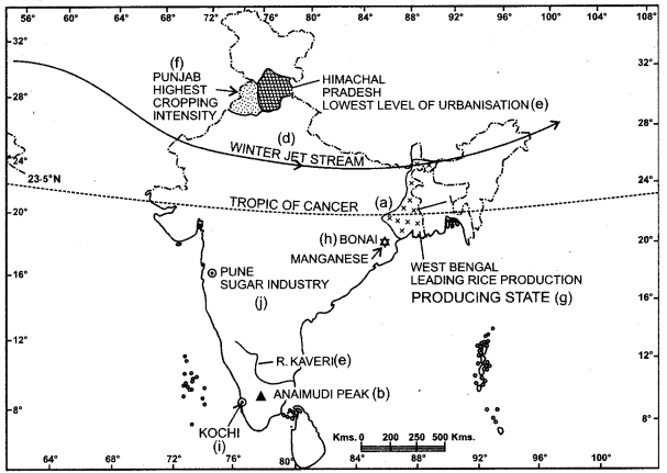
On the outline map of India provided :
(a) Mark and name the 23-5 °N latitude.
(b) Mark and name the Anaimudi peak.
(c) Trace the course of River Kaveri.
(d) Mark with an arrow the direction of winter jet stream over India.
(e) Mark and name the state with the lowest level of urbanisation.
(f) Shade the state with the highest cropping intensity.
(g) Shade and name the leading state for rice production.
(h) Mark and name a centre for manganese production.
(i) Mark Kochi seaport.
(j) Mark and name the Pune centre of sugar industry in Maharashtra.
Note: All the map work, including legend (Index)
should be done on the map sheet only.
Answer:

PART-II (40 Marks)
Answer any four questions.
Question 3.
(a) (i) Briefly explain the geological evolution of the peninsular plateau. [4]
(ii) Define the terms Lagoon and Delta with an example of each from the Indian region.
(b) Name the two rivers that make the easternmost and the westernmost limits of Kumaon Himalayas. [2]
(c) Distinguish between the terms Flora and Forest. [2]
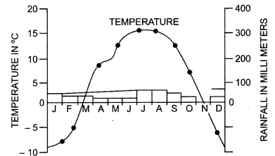
(d) Study the climatic graph of station A given below and answer the questions that follow :[2]

(i) Give a reason as to why extreme low temperature is indicated for station A.
(ii) Name the month when the highest amount of rainfall is received.
Answer:
(a) (i) During the pre Cambrian era, there was a large depression in which the sediment was deposited and a block of crystal rock known as the Peninsula Plateau came out of this depression and never submerged again. This stable land has behaved as a rigid and inflexible block throughout its geological history and is often compared to a horst.
(ii) Lagoons are saltwater ’lakes, separated from the main sea by sand bars and spits, ex : Chilka lake.
Delta: In the lower course of the river, the river divides itself into several channels known as distributaries and in between these distributaries, sediments are deposited forming a triangular shaped feature which is known as Delta, ex: Ganga Brahmaputra delta.
(b) River Satluj and River Kali
(c)
| Flora | Forest |
| (i) It refers to plants of a particular region or period listed by species and considered as a group. | (i) This term is generally used to denote a large area covered by trees and shrubs. |
| (ii) Different flora can be found in different types of environment. | (ii) Forests are thick with growth of trees. |
| (iii) Flora can be put in category, e.g. Indian species brought from Indo-Tibet are known as Boreal. | (iii) Forests provide us just one land-scape. |
(d) (i) Station A is at a high altitude and is surrounded by lofty mountains. It is out of influence of the monsoon.
(ii) The months of July and August receive the highest rainfall.
Question 4.
(a) Define an urban area according to the latest census. [2]
(b) (i) What is the present population of India?[2]
(ii) With reference to the percentage of world population, state India’s position in the world.
(c) What is the difference between arithmetic density of population and physiological density of population? [2]
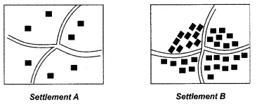
(d) Study the given types of rural settlements and answer the questions that follow : [4]

(i) Identify the two types of settlements A and B. State one characteristic feature each of the two settlements.
(ii) What is the main economic function performed in a rural settlement?
Answer:
(a) An urban area, according to the latest census, is defined as follows :
(i) All places with a Municipality, Corporation, Cantonment Board or Notified Town, Committee, etc., are included as Urban areas.
(ii) All other places which satisfy the following criteria : A minimum population of 5000. At least 75% of male working population engaged in non-agricultural pursuits. A density of population of at least 400 persons per square km.
(b) (i) According to the census 2011, the population of India was 1.21 billion and it can be estimated that the present population of India will be more than 1.21 billion.
(ii) India’s position in the world is second with reference to the world population.
(c)
| Arithmetic Density of Population | Physiological Density of Population |
| Total population/total area | Total population/net cultivated area |
(d)
(i)
| Disperse | Compact |
| Cattle rearing or lumbering are the main occupation. | Agriculture is the main occupation. |
(ii) The main economic functions performed in a rural settlement are :
Agriculture, Mining, Forestry, Fishing and Lumbering.
Question 5.
(a) What is meant by environmental management? Why is there a need for environmental management in India ? [2]
(b) What is the percentage of net sown area and net forest area of India in present times ? [2]
(c) Mention any three advantages of well irrigation in India. [3]
(d) Name one perennial canal in each of the following states: [3]
(i) Uttar Pradesh
(ii) Punjab
(iii) Tamil Nadu
Answer:
(a) Environmental management is a process of planning, review, assessment, decision making and the like which is essential in real life situation of limited sources and changing priorities.
The need of management of environment has emerged as a major concern before the world community and this need is felt more urgently in developing countries like India. New innovations such as sustainable/clean technologies, environmental auditing, eco-friendly products etc., have been developed to save our environmental from degradation.
(b) The Net shown area of India is 46.5%. Net Forest area of India is 69.78 million hectares or 22.86%.
(c) Three advantages of well irrigation are :
(i) Well is the simplest and the cheapest source of irrigation as the farmer has to pay regularly for canal irrigation which is not the case with well irrigation.
(ii) Well is an independent source of irrigation and can be used as and when the necessity arises. It is not controlled by other agencies.
(iii) Several chemicals such as Nitrates, Chlorides, Sulphates are mixed in well water naturally which add to the fertility of the soil.
(d) (i) Uttar Pradesh – Upper Ganga Canal
(ii) Punjab – Upper Bari Doab Canal
(iii) Mettur Canal System
Question 6.
(a) State a difference between wet farming and dry farming. [1]
(b) (i) Mention the climatic conditions required for growing coconut in India. [3]
(ii) Name two areas of coconut production in Sri Lanka.
(c) Suggest any two methods for fish conservation. [2]
(d) (i) Name a major state for the development of each of the following : [4]
(1) Thermal Power
(2) Hydroelectric Power.
(ii) State two advantages of using biogas as a source of energy.
Answer:
(a)
| Wet Farming | Dry Farming |
| Farming practised in regions receiving more than 75 cms of annual rainfall is called Wet farming. For e.g. Rice. | Farming practised in regions with less than 75 cms of annual rainfall is called Dry farming. For e.g. Millets. |
(b) (i) Climatic conditions required for growing coconut:
Temperature – 25° C to 30° C.
Rainfall – 125 to 130 cm well distributed.
Frost and draught are very harmful to coconut.
(ii) Two areas of coconut production in Sri Lanka are :
- Nigombo
- Kurunegala
(c) Two methods of fish conservation are :
(i) Restocking of Overfished Waters :
Restocking of such areas are necessary to avoid the complete disappearance of fishes from these areas.
(ii) Checking Indiscriminate Fishing :
Indiscriminate killing of immature fish should be stopped immediately.
(d) (i) 1. Thermal Power: Jharkhand, Chhattisgarh, West Bengal
2. Hydel Power: Himachal Pradesh, U.P., Tamil Nadu
(ii) Two advantages of using Biogas are :
1. As a by-product, biogas plant produces enriched fertilizers.
2. The use of biogas improves sanitation and provides smokeless and efficient cooking fuel. It can also be used for lighting and power generation.
Question 7.
(a) Give any three reasons to explain why railways are well developed in the Northern plains of India.[3]
(b) Give one point of difference between Golden Quadrilateral Highways and National Highways. [2]
(c) Explain the relationship between transport and industrial development. [3]
(d) What are the two ways in which Radio can be considered as a powerful means of communication ? [2]
Answer:
(a) Railways are well developed in the Northern plains of India because; the North Indian plain is densely populated and has a highly developed agriculture and industry.
Large scale urbanization has also helped in the development of Railways. The North Indian plain is a plain lavelled land which is the most favourable condition for the development of railways.
Railways developed more in the economically advanced areas where the need for the railway network is felt more. The huge agriculture produce from the grain market of the North Indian plain are transported by railways to different parts of the country.
(b) The main roads which connect the state capitals, big cities and important ports are constructed and maintained by the Central Public Works Dept, and are known as Highways.
Golden Quadrilateral Super Highway connecting Delhi-Mumbai-Chennai-Kolkata – Delhi by six lane super highways is being implemented by National Highway Authority of India.
(c) Transport and Industry are closely related to each other. Cheap and efficient transport is essential for localization and growth of industries. Transporting facilities are required for carrying raw materials and labour force to the manufacturing site and for carrying
manufactured goods to the market. No industrial growth is possible without transport; for e.g. iron & steel industry uses coal, iron ore and manganese as the basic raw material. These are heavy raw materials which require cheap transport because they cannot bear higher transport cost. Earlier growth of industries took place near the major ports like Kolkata, Mumbai and Chennai because these ports were connected with their surrounding areas by a close network of roads and railways,
(d) Radio is a powerful medium which provides all sorts of useful information, news and variety of entertainment. AIR broadcasts in 24 languages and 146 dialects with a total network of 225 broadcasting centres covering 91.4% of the area, almost reaching the entire population in a linguistically diverse country like India.
Question 8.
(a) Name a major industrial region of India and state any three factors that are responsible for the growth of this region. [4]
(b) State two significant factors influencing the location of Aluminium industry in India. [2]
(c) Name any one important centre of production for the following : [2]
(i) Ships
(ii) Cement
(iii) Automobiles
(iv) Aircrafts
(d) State any two advantages of tourism in India. [2]
Answer:
(a) Mumbai-Pune Industrial region is a major industrial hub of India.
Three factors responsible for the growth of this industrial region are :
(i) The region is well connected by a network of roads and railways which helps in easy transportation of raw cotton for the cotton textile industry and the finished goods.
(ii) Cheap hydro electricity is readily available from the Western ghats.
(iii) Cheap labour force can be drawn from the surrounding areas.
Mumbai is a very important port which helps in import of machineries and export of finished products. In addition to cotton textile industry, chemicals, engineering goods, oil refineries, petrochemicals, fertilizers, shipbuilding and automobile industries are also developed.
(b) Two significant factors influencing the location of aluminium industry are the availability of bauxite as the production of 1 MT of aluminium requires 6 MT of bauxite and 18573 kwh of electricity. This clearly indicates that the availability of bauxite and electricity are the two most significant factors which influence the localization of this industry.
(c) Any one centre of production :
Ships: The Garden Reach Workshop at Kolkata.
Cement: Kymore in M.P.
Automobiles : Maruti Udyog Ltd. at Gurgaon in Haryana.
Aircraft: Hindusthan Aeronautics Ltd. – Bengaluru.
(d) The two advantages of tourism are :
(i) It helps in improving infrastructure.
(ii) Development of local handicraft and cultural activities.
Question 9.
(a) Explain the meaning of a planning region. [2]
(b) Name two centres each in Chhattisgarh where the following are mined : [2]
(i) iron ore (ii) bauxite
(c) Why was the state of Chhattisgarh created?
Name two of its bordering states. [3]
(d) Mention three factors which have influenced the development of the Electronic City of Bengaluru. [3]
Answers:
(a) A planning region is a self-created living organism having a lifetime which not only supports the life in the region but also radiates unifying forces that enable the region to be a unified regional space so as to facilitate the practice of regional planning.
(b) Two centres each in Chhattisgarh where the following mined are :
(i) Iron Ore : Bailadila in Bastar district and Dali Rajhara in Durg district.
(ii) Bauxite : Surguja & Raigarh.
(c) Chhattisgarh is the 26th state of the Indian Union which was curbed out of M.P. for administrative convenience and social and economic harmony and functional unity.
(d) Three factors which have influenced the development of electronic city of Bengaluru are :
- The incentives by the state and central governments.
- The strategic location of the city in the middle of the Indian Peninsula and a close network of roads and railways.
- A large no. of Indian and foreign multinational companies have invested a huge sum of money to nourish electronic industries in this city.
