ICSE Geography Previous year Question Paper 2017 Solved for Class 10
- Answers to this Paper must be written on the paper provided separately.
- You will not be allowed to write during the first 15 minutes.
- This time is to be spent in reading the question paper.
- The time given at the head of this Paper is the time allowed for writing the answers.
- Attempt seven questions in all.
- Part I is compulsory. All questions from Part I are to be attempted.
- A total of five questions are to be attempted from Part II.
- The intended marks for questions or parts of questions are given in brackets [ ].
- To be supplied with this Paper: Survey of India Map Sheet No. 45D/10
- And 20 cm of twine.
NOTE:
- In all Map Work, make wise use of arrows to avoid overcrowding of the map.
- The extract of Survey of India Map Sheet No. 45D/10 must not be taken out of the examination hall. It must be handed over to the Supervising Examiner on completion of the paper.
- The Map given at the end of this question paper must be detached, and after marking, must be fastened to your answer booklet.
- All sub-sections of the questions attempted must be answered in the correct serial order.
- All working including rough work should be done on the same answer sheet which is used to answer the rest of the paper.
Part-I [30 Marks]
(Attempt ALL Questions from this part)
Question 1.
Study the extract of the Survey of India Map sheet No. 45D/10 and answer the following questions:
(a) Give the six figure grid reference for: [2]
- The highest point in this map extract.
- Surveyed tree north of Rampura Khera.
Answer:
- 088065
- 072073
(b) On which bank of Sukli Nadi lies: [2]
- Butri
- Padrugarh [2]
Answer:
- North – West
- North – East
(c) Differentiate between the drainage pattern shown in grid square: [2]
- 0704
- 0705
Answer:
Grid 0704 has Trellis pattern whereas 0705 has radial drainage pattern.
(d) The region in this map extract receives seasonal rainfall. Give two reasons for your answer. [2]
Answer:
- River, wells and tanks are dry.
- Vegetation – fairly dense scrub.
(e) Calculate the distance in km between settlement Bhatana and Makawal along the cart track. [2]
Answer:
Indirect distance = 12 cm
1cm on the map represents = 500
12cm on the map represent = 500
(f) State the Compass direction of the following: [2]
- Dattani from Marol.
- Dhavli from Makawal.
Answer:
- South – East
- North – East
(g) 1. Mention a social activity of people living in Marol. [2]
2. What is the main occupation of the people living in this region?
Answer:
- Monthly Fair
- Agriculture – Yellow wash
(h) What do you understand by: [2]
- The black broken line in 0807
- The vertical black line close to Easting 10
Answer:
- Disappearing drainage
- Longitude line 35°
(i) What is the main source of water supply to Bhatana? Give a reason for your answer. [2]
Answer:
Tank
(j) 1. Name one natural feature in the grid square 0905. [2]
2. Identify one man made feature in the grid square 1003.
Answer:
- Cause way
- Post office
Question 2.
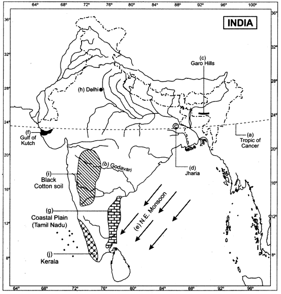
On the outline map of India provided:
(a) Draw and name the Tropic of Cancer. [1]
(b) Label the river Godavari. [1]
(c) Mark and name the Garo Hills. [1]
(d) Mark C on the coal fields in Jharia. [1]
(e) Mark with an arrow and name the NE monsoon over the Bay of Bengal. [1]
(f) Shade and name the Gulf of Kutch. [1]
(g) Shade and name the coastal plain that receives rainfall in October-November. [1]
(h) Mark with a dot and name Delhi. [1]
(i) Shade a region with Black Cotton Soil. [1]
(j) Use an arrow to point at a densely populated state in South India. [1]
Answer:

Part II [50 Marks]
Attempt any five questions from this part
Question 3.
(a) Mention the four seasons that prevail in India stating the months for each. [2]
Answer:
- The cold weather season starts in November and continues till March.
- The hot weather season start in March and ends in May.
- The season of the advancing monsoon starts in June and lasts until September.
- The season of the retreating monsoon starts in October and Novemeber.
(b) State the agricultural benefits derived from : [2]
- The Westerly Depressions in Punjab.
- The Kalbaisakhi in Assam.
Answer:
- These depressions are very useful for wheat, a major crop of Punjab.
- These local winds are accompanied by thunderstorms and bring rainfall. This rain is good for jute and rice.
(c) Give a reason for each of the following: [3]
- Kolkata receives heavier rain than Lucknow.
- The Summer Monsoon winds blow over the Arabian Sea from the Southwest.
- Thar is a desert.
Answer:
- Kolkata is located near the coast whereas Lucknow is far from coast. Monsoon winds get dry as the distance from the sea increases.
- The South-East Trades are attracted towards India due to low pressure prevailing on the land mass. After crossing the Equator, they are deflected towards the right due to Coriolis Effect and blow into India as South -West Monsoon.
- Thar is a desert because of scanty rainfall. The region receives scanty rainfall because the Aravali range is parallel to the direction of the prevailing winds, so it does not offer any obstacles in the way of winds.
(d) Study the climatic data given below and answer the questions that follow: [3]

- What is the annual range temperature of the station?
- What is the total annual rainfall experienced by the station?
- Why would it be correct to presume that the station lies in the interior and not on the coast?
Answer:
- 36.2 °C – 12 °C = 24.2 °C
- 1.5 + 0.1 + 0.0 +1.4 + 1.1 + 21.0 + 25.3 + 27.2 + 24.0 + 9.4 + 1.5 + 0.4 = 112.9 cm
- Temperature range is very high so we can conclude the station is away from the equable effect.
Question 4.
(a) Mention two differences between Alluvial Soil and Black Cotton Soil. [2]
Answer:
| Alluvial Soil | Black Soil |
| 1. Alluvial soil is very fertile as it is rich in mineral nutrients like potash and lime. 2. Most of alluvial soil is derived from the sediments deposited by rivers. | 1. The black soils are made of extremely fine material, i. e., clayey material. 2. The soil is well-known for its capacity to hold moisture. |
(b) Name an area in India in which each of the following processes take place: [2]
- Sheet erosion
- Gully erosion
Answer:
- Hilly areas of Uttrakhand and Himachal Pradesh
- Madhya Pradesh
(c) What is soil conservation? State a method of soil conservation in the: [3]
- Arid and Semi-Arid region.
- River valleys prone to flood.
Answer:
Soil erosion is the removal of soil by the forces of nature, particularly wind and water. Soil erosion mainly takes place due to man’s activities such as deforestation, overgrazing of cattle, faulty methods of cultivation.
- Aforestation, Restricting grazing of animals
- Constructing dams
(d) Name the soil which: [3]
- Is good for cultivation of sugarcane.
- is acidic in nature.
- occurs exsitu.
Answer:
- Alluvial and Black soil
- Laterite
- Alluvial
Question 5.
(a) How do trees in the Tropical desert forests adapt themselves to the dry climate? [2]
Answer:
Trees remain small, it saves surface through which water evaporates.
- Get round and develop a green cylindrical stems which helps to perform photosynthesis.
- Develop an extended root system close to the surface and still collect a lot of water during scanty rainfall.
(b) Name the tree as per its characteristics given below: [2]
- The wood is hard and suitable for ship building.
- The stilt roots are Underwater during high tide.
Answer:
- Rosewood
- Mangroves trees
(c) Explain why the forest cover in India is shrinking. [3]
Answer:
1. Overutilisation of forests: In the earlier days, man’s needs were limited. He was dependent on forests only for a few things, although a lot of things can be obtained from forests. Forests are being used to fulfil man’s needs directly and indirectly. We are obtaining wood, barks, leaves, rubber, medicine, dyes, food, fuel, fodder, etc., from forests.
2. Colonial Plans: The greatest damage inflicted on Indian forests was during the colonial period due to the expansion of the railways, agriculture, commercial and scientific forestry and mining activities.
3. Agricultural expansion: Even after independence, agricultural expansion continues to be one of the major causes of depletion. Between 1951 and 1980, according to the Forest Survey of India, over 26,200 sq. km. of forest areas were converted into agricultural lands all over India.
(d) Name the natural vegetation found in the following regions: [3]
- The western slopes of the Western Ghats.
- The Nilgiris.
- Western Rajasthan.
Answer:
- Tropical Evergreen Forests
- Tropical Evergreen Forests and Tropical Desert
- Tropical Desert
Question 6.
(a) Give a reason for the significance of irrigation in : [2]
- Punjab.
- Rajasthan.
Answer:
- Punjab is an agriculture state so lot of water is required for irrigation.
- Rajasthan is a dry state so irrigation is required to cultivate the crop and drinking.
(b) Name a state where: [2]
- Tube wells are common.
- Tank irrigation is popular.
Answer:
- Maharashtra
- Tamil Nadu
(c) Give one geographical reason for each of the following : [3]
- Sprinkler irrigation is practiced in arid and semi-arid regions.
- A tube well should be installed in a fertile and productive region.
- Canal irrigation is more suitable in the Northern Plains.
Answer:
- To minimize the loss of water.
- So that there is demand for irrigation and the cost involved in the construction and operation of the tube well can be recovered by the increased farm production.
- Canal irrigation is suitable for Northern India because
- Low relief area
- Even surface so digging is easy
- Deep fertile soil which helps in recovering the cost of construction of canals.
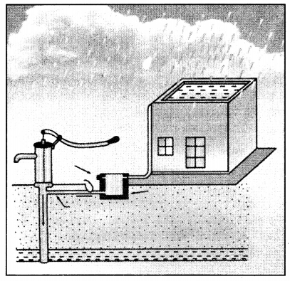
(d) Study the diagram below and answer the questions that follow: [3]

- Name the activity shown in the diagram.
- Give two objectives of the activity named in (d) (i).
Answer:
- Rain water harvesting
- To overcome the inadequacy of surface water to meet our demands.
To check decline in groundwater levels.
Question 7.
(a) Give the names of four important types of iron ore found in India. [2]
Answer:
Magnetite, Hematite, Limonite and Siderite.
(b) Name the following: [2]
- An offshore oil field in the Gulf of Cambay.
- An oil refinery in Bihar.
Answer:
- Mumbai High
- IOC
(c)
- Name the state that produces the largest amount of limestone. [3]
- State two uses of limestone.
Answer:
- Madhya Pradesh
- It is a basic input in the cement industry.
It is used in the production of Portland cement.
(d) State an important industrial use of : [3]
- Manganese
- Coal
- Aluminum
Answer:
- Iron and Steel manufacturing
- Iron and Steel manufacturing
- Use to making pots and pans because good conductor of heat.
Question 8.
(a) What is Mixed farming? Mention any one benefit of Mixed farming. [2]
Answer:
Mixed farming is a technique of farming under which equal importance is given to rearing of animals along with cultivation of crops.
Advantage: Farmers remain busy in their work throughout the year.
(b) Give the Geographical requirements for the cultivation of Sugarcane. [2]
Answer:
Temperature: 20°C to 30°C, hot and moist climate.
Rainfall: 75 cm to 150 cm and grows best on irrigated land.
Soil: Well drained fertile soil. It also requires plenty of manure and fertilizers.
(c) Explain the following terms and name the crop with which each is associated: [3]
- Retting
- Ratooning
- Ginning
Answer:
1. Retting is associated with jute. Retting is a microbiological process which loosens the outer bark and makes it easier to remove fibres from the stalk. Plant is dipped in stagnant water for 2-3 weeks in order to soften the outer bark.
2. Ratooning is a method of sugarcane cultivation. In this method the cane is cut close to the ground. After sometime the stem begins to grow again and produces a second crop called ratoon.
3. It is associated with cotton. Ginning is a process by which seeds are separated from the fibre.
(d) Give geographical reasons for the following: [3]
- Regular pruning is essential for tea bushes.
- Coffee beans are roasted.
- Millets are known as dry crops.
Answer:
1. Pruning is done to keep the shrub at a convenient height of about 40 to 50 cm. It encourages the growth of new shoots with softer leaves.
2. Roasting is done to improve the flavour and taste of coffee. Roasting gives brown colour and pleasing aroma.
3. Millets need rainfall ranging between 50 cm – 120 cm, that is, they do not need much rainfall. Because of this feature, millets are called ‘DRY’ crops.
Question 9.
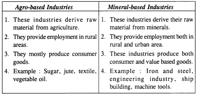
(a) Differentiate between Mineral-based Industry and Agro-based industry giving one example for each. [2]
Answer:

(b) ‘Though Uttar Pradesh has the largest number of sugar mills yet Maharashtra is the largest producer of sugar’. Give any two reasons to justify the statement. [2]
Answer:
- Climate: Sugarcane is a tropical crop. Peninsular India has tropical climate which gives higher yield per unit area as compared to north India.
- Higher sucrose: Due to favourable climatic conditions, the sucrose content is also higher in tropical variety of sugarcane in the south.
- Long crushing period: The crushing season is also much longer in the south than in the north. For example, crushing season is of nearly four months in the north. Whereas it is of nearly 7-8 months in the south.
(c) Give the geographic term for each of the following: [3]
- Non-mulberry silk produced in Madhya Pradesh.
- Rejected cane after cmshing.
- The rearing of silk worms to obtain silk.
Answer:
- Tussar Silk
- Bagasse
- Sericulture
(d) With reference to the cotton textile industry answer the following questions: [3]
- Give two reasons why Mumbai is an important cotton textile industry.
- Mention two more important centres of cotton textile industry in India.
Answer:
- (a) Raw material is grown in Maharashtra itself and is also easily available from neighbouring states of Gujarat and Madhya Pradesh.
(b) Humid climatic condition in Mumbai favours spinning of yam.
(c) Cheap hydroelectric power is available. - Ahmadabad and Jamnagar
Question 10.
(a) ‘The Iron and Steel industry constitutes the backbone of modem industrial economy.’ Give two reasons to justify the statement. [2]
Answer:
Iron and steel industry is called the basic industry because :
- It is the industry which lays the foundation of rapid development of other industries such as heavy engineering, defence equipment, automobiles, aeroplanes, etc.
- It is also helpful in providing employment.
(b) 1. Name an Iron and Steel Industry set up in Orissa with the help of a famous German firm. [2]
2. From where does the industry named in b (i) get its iron ore and manganese?
Answer:
- Rourkela
- Iron ore – Bonaigarh, Mayurbhanj, Manganese – Barajamda
(c) Name a manufacturing centre for each of the following industries : [3]
- Aircraft
- HMT
- Railwaycoaches
Answer:
- Koraput
- Bengaluru
- Kapurthala
(d) Name two products each of the following industries: [3]
- petrochemical industry
- heavy engineering industry.
- electronic industry.
Answer:
- Synthetic fibers, plastics
- Wrist watch, drilling machines
- Computers, Television
Question 11.
(a) Mention two reasons why more people use railways rather than airways. [2]
Answer:
- Railway is cheap mode of transportation.
- Railway can carry bulky raw material.
(b) Why is inland waterways declining in its importance? Give two reasons for your answer. [2]
Answer:
- Water transport as a whole is much slower than its roads, rail or air competitors.
- It provides access to limited areas.
(c) What do you mean by the following: [3]
- Sewage
- Eutrophication
- Recycling
Answer:
1.The waste water discharged from domestic premises like residences, institutions and commercial establishments is known as sewage.
2. The process by which a body of water acquires a high concentration of nutrients, especially phosphates and nitrates is known as eutrophication.
3. Recycling involves the collection of used and discarded materials, processing these materials and making them into new products. It reduces the amount of waste that is thrown into the community and the air fresher , to breathe.
(d) ‘Methane is an air pollutant that causes Greenhouse effect.’ Name three sources of this gas. [3]
Answer:
- Mining
- Landfills
- Wet lands
